
Signature trail Höga Kusten
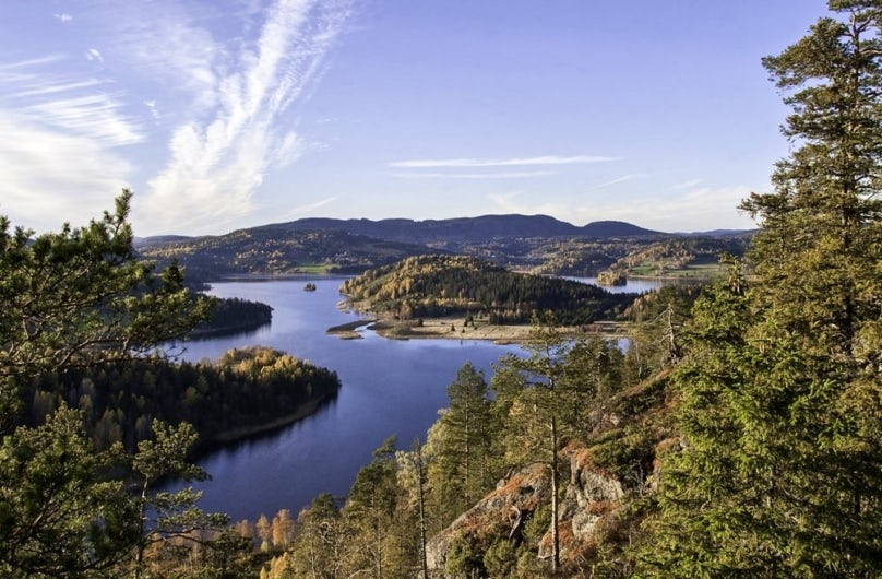
The Höga Kusten-leden trail is a beautiful stretch along coastline and ancient forest, with breathtaking viewpoints and deep woodlands.
The trail winds its way through nature reserves, a natural World Heritage Site and a national park, where Hornöberget is the starting point and Örnsköldsvik the destination. Along the way, 135 kilometres of magnificent views and dramatic landscapes await along the world’s highest coastline, divided into 9 stages.
The hiking trail is one of STF’s signature trails – an especially beautiful, quality-assured multi-day hike.
Quick facts
Map of the Signature trail Höga Kusten
Navigate past map or other external content.This map is a planning tool and should not replace a physical map and compass. The service “Naturkartan” (opens in new tab) is operated by a company called “Outdoor map”. Please note that trail information is owned and updated by the respective trail administrator (e.g. municipality or county administrative board).
Discover the Signature trail Höga Kusten
On a hike through the World Heritage Site of the High Coast you are met by an outstanding variety of nature experiences. Archipelago, enchanted forests, boulder fields, bathing coves and rock crevices follow one after another. The middle section of the trail is dominated by the area around Skuleberget and Skuleskogen National Park. The stretch through the national park is one of the highlights of the hike. Here, alongside dark tarns, sweeping views, babbling brooks and deep ravines, you will find the spectacular Slåttdalen Crevice.
See and do along the trail
Day five, when the hike ends at Skuleberget, is a short stretch so there is time to explore the area. For example, there is exciting climbing with the Skuleberget Via Ferrata (opens in new tab).
Don’t miss
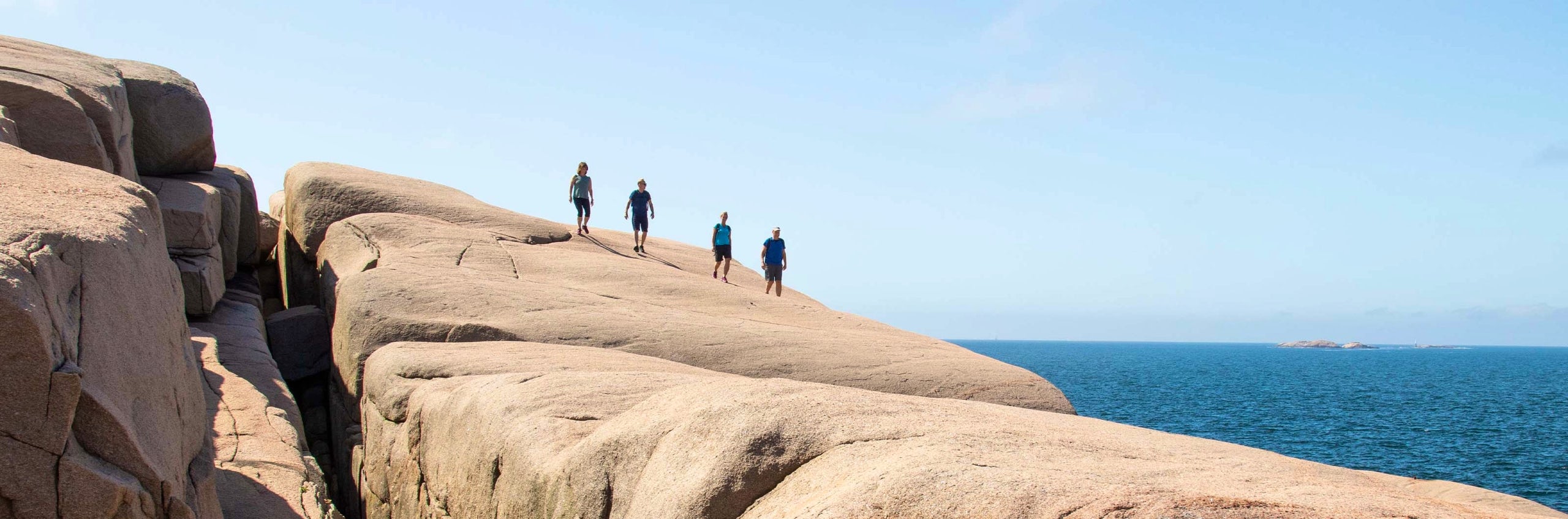
Start really early on a nice day and experience the sunrise from a cliff with a view out over the sea and archipelago.
Getting to the trail
The Höga Kusten Trail can be hiked in either direction, meaning there are two starting points – Hornöberget and Örnsköldsvik.
Hornöberget
Starting point (opens in new tab)
At the starting point there is a large parking lot where you can leave your car. More information can be found at hogakustenleden.com (opens in new tab). You can also get there by public transport between Härnösand and Örnsköldsvik. Current bus timetables can be found at www.dintur.se (opens in new tab).
Örnsköldsvik
Starting point (opens in new tab)
The start in Örnsköldsvik is at Stadsträdgården and you can travel to Örnsköldsvik by public transport by train or bus. Current bus timetables can be found at www.dintur.se (opens in new tab).
Trail markers
The trail is clearly marked with orange markings on trees, poles and rocks. When the trail crosses a road there are signs with the trail symbol.
Stages of the Signature trail Höga Kusten
Stage 1: Hornöberget–Lövvik
Stage 1: Hornöberget–Lövvik 11 kilometres, 5–6 hours of hiking
Accommodation: Spend the first night at Snibbens Camping (opens in new tab) right next to the abutment of the High Coast Bridge.
The High Coast Trail starts at Hornöberget by the northern abutment of the High Coast Bridge. Here you can park your car free of charge for the duration of your hike. Inside the hotel there is a tourist information office that is staffed during the summer. There is an opportunity to fill up on water at the start.
The trail then passes under the High Coast Bridge, follows the old coastal road from Hornöberget to Nyadal. Via the Lövvik bridge you continue across the Svartnora strait to the Svartnora peninsula and on over a couple of summits before reaching the stage destination in Lövvik.
Stage 2: Lövvik-Gavik
26.8 kilometres, 10-12 hours of hiking
Accommodation: Fjärdbotten shieling (timbered cabins with sleeping platforms). There is also the option to camp here. At the end of the stage in Gavik, GaviksTorpets B&B (opens in new tab) offers comfortable accommodation.
About two kilometres from the stage start there is a detour, 800 metres from the trail, to the summit of Valkallen, which is well worth the effort. Here you get one of the High Coast Trail’s most magnificent views! Continue north along Grönsvik Bay. A tip is to take the short detour to Rödhällorna, where the red Nordingrå granite – Ångermanland’s provincial stone – is clearly visible.
About 10 kilometres into stage 2 you can easily shorten your hike by staying overnight at Fjärdbotten shieling, located on the headland at Häggnäset. Here there are three timbered cabins and a larger building with a long table and benches. There are also camping options and two reliable cold springs. Note that parking for 3–4 cars is available by the road, approximately 900 metres from the shieling. The trail then continues over Lidenipan and ends at Gavik with a small car park in Norr-Gavik at the end of the public road.
Stage 3: Gavik–Lappudden
9.4 kilometres, 3 hours of hiking
Accommodation: Shelter at Älgaberget
This is an easy stage that largely follows gravel roads with two fine detours to Älgaberget and Rödklitten. The stage destination Lappudden is beautifully situated at the outermost tip of a headland jutting out into Vågsfjärden. Vågsfjärden is a telling example of the land uplift process – despite its name, it has been a freshwater lake for 150 years. The life in the water, however, still speaks of former times: although the surface lies just over a metre above sea level, crustaceans that properly belong in brackish water still survive here.
Stage 4: Lappudden-Ullånger
14.6 kilometres, 6-7 hours of hiking
Accommodation: In Ullånger, you’ll find Ullångers Hotell & Restaurang (opens in new tab). For those looking for simpler accommodations, there’s The Tree Cube, an architect-designed shelter that is literally a cube in a tree.
Shortly after the stage start you can make a detour to Nordingrå, where you will find services including a grocery shop. The stage destination Ullånger has a broad range of services with a grocery shop, café, specialist shops and arts and crafts. Ullånger is also a bus hub with free commuter parking. During the summer season there is also a boat connection from Ullånger to Ulvön and other islands with the High Coast boats.
Stage 5: Ullånger–Skuleberget
20.8 kilometres, 7-9 hours of hiking
Accommodation: Camping spots are available a few kilometres before the stage destination. Camping is only permitted at designated sites within the national park.
After a short climb from Ullånger you reach Mäjasjön shielings. This is not actually a shieling in the traditional sense, but rather a heritage site. The dozen or so buildings here have been gathered from various locations in the area and carefully reconstructed on site. Between Mäja and Docksta the trail follows the old coastal road. Don’t miss the detour to the summit of Fäberget – the roughly 1.5 kilometres to the top are highly recommended.
Continuing along the trail you soon reach Docksta, which offers most services you could need: grocery shop, hardware store, petrol station, restaurants and accommodation. Just after the village of Docksta the climb up Skuleberget begins – an iconic landmark of the High Coast offering a magical view. On the mountain there are traces of the highest coastline after the Ice Age, and Skuleberget in fact holds the world’s highest coastline at 286 metres above sea level.
Stage 6: Skuleberget–Entré Syd
10.9 kilometres, 3–5 hours of hiking
Accommodation: Along the stage there are overnight cabins in Skuleskogen National Park. For camping, designated camping sites apply within the national park.
From Skuleberget the trail leads down towards Veåsand and on up Getsvedjeberget, where you will find a “Pulpit”. After a while you reach Entré Syd, the southern entrance to Skuleskogen National Park. Here there are car parks, information about the national park, weather-sheltered seating, benches, tables and dry toilets.
Stage 7: Entré Syd–Entré Nord
7.5 kilometres, 2–3 hours of hiking
Accommodation: Shelter at Småtjärnarna
From Entré Syd you hike into the national park, where camping is only permitted at designated sites. One of the highlights of the park is the Slåttdalen Crevice. Due to safety risks, hiking through the crevice is not recommended; instead, the trail passes west of it and offers fine viewpoints and photo spots.
The stage ends at Entré Nord, the northernmost entrance to the national park, where there are information boards, benches, a fire pit, toilets and waste disposal.
Stage 8: Entré Nord, Skuleskogen National Park–Balesudden
20 km, 6–8 hours of hiking
Accommodation: STF Kajkanten Höga Kusten, open overnight shelter in Bodviken
Follow the gravel road down towards the village of Näske and continue towards Köpmanholmen and on along the coast towards Sandlågan. The stage ends at Balesudden Nature Reserve, which offers varied terrain ranging from dark spruce forests to open mountain plateaus at over 150 metres elevation. The reserve, which covers 923 hectares and was established in 1985, is one of the most scenic areas on the stage. Six kilometres of the trail pass through the reserve, and a two-kilometre detour takes you to the viewpoint on Balesberget. On the way there you pass Balestjärnen, a small tarn known for its setting and its exceptionally clear water.
Stage 9: Balesudden–Örnsköldsvik
18.8 kilometres, 8–10 hours of hiking
Accommodation: Once in Örnsköldsvik there is a wide range of accommodation options as well as grocery shops and restaurants.
From Balesudden the trail continues along the gravel road at Bäckfjärden, past the village of Bäck and on to Utby. It then climbs over the Vitsjö massif and descends to Svedjeholmen. The trail passes through the community, across the bridge at Moälven, and up towards Varvsberget. Here you get a fantastic view over Örnsköldsvik before walking down to the town centre and the stage destination.
Read more about the stages along Höga Kusten trail here (opens in new tab).
STF-accommodation in Höga Kusten


STF Pelle Åbergsgården Höga Kusten

STF Skutskepparn and Högbondens Fyr
More pages about hiking

All about hiking
On this page you will find helpful tips and information for your hike.

Hiking trails in Sweden
On this page we present a selection of popular and high-quality trails across the country.
Signature trails
STF has selected some of the most spectacular routes in the country and brought them together under the name Signature Trails.