
Signature trail Höga Kusten
Signature trail Höga Kusten meanders through a number of nature reserves, a national park and a natural heritage site. This guarantees great nature experiences. Hornöberget is the start and Örnsköldsvik is the destination; in between there are 140 kilometres of majestic views and dramatic nature along the highest coastline in the world. The trail is divided into 7 stages of varying lengths.
Signature trail Höga Kusten is one of STF’s signature trails. View the collection of STF’s signature trails.
Signature trail Höga Kusten in short
Map of the Signature trail Höga Kusten
Navigate past map or other external content.This map is a planning tool and should not replace a physical map and compass. The service “Naturkartan” (opens in new tab) is operated by a company called “Outdoor map”. Please note that trail information is owned and updated by the respective trail administrator (e.g. municipality or county administrative board).
Discover the Signature trail Höga Kusten
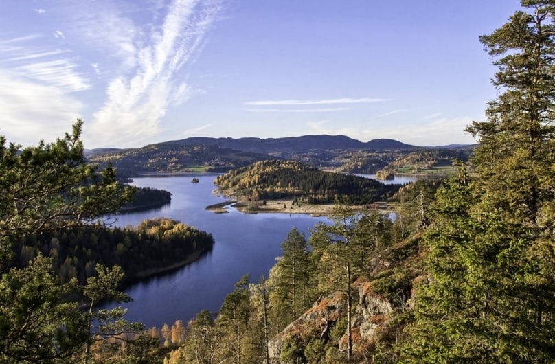
During a hike through the world heritage site the High Coast, you encounter a unique variety of nature experiences. Archipelago, magical forests, raised shingle beaches, swimming coves and rock crevices all feature along the hike. The first three days are relatively long in a partly hilly landscape, so back extra snacks! The middle part of the trail is dominated by the area around Skuleberget and Skuleskogen National Park. The section through the national park is one of the highlights of the hike. In addition to dark woodland lakes, wide views, rippling streams and deep ravines, there is also the spectacular rock crevice Slåtterdalsskrevan.
See and do along the trail
Day four, when the hike ends at Skuleberget, is a short section, so there is time to experience the area. For example, there is exciting climbing with Via Ferrata.
Don’t miss
Start really early on a nice day and experience the sunrise from a cliff with a view out over the sea and archipelago.
Transport to the trail
The Höga Kusten Trail can be hiked in either direction, meaning there are two starting points – Hornöberget and Örnsköldsvik.
Hornöberget
Starting point (opens in new tab)
At the starting point there is a large parking lot where you can leave your car during your hike. More information can be found at High coast trail (opens in new tab). You can also get there by public bus between Härnösand and Örnsköldsvik. Current bus schedules can be found at www.dintur.se (opens in new tab). For questions about the buses, contact DinTur at +46(0)771-100 110.
Örnsköldsvik
Starting point (opens in new tab)
The start in Örnsköldsvik is at Stadsträdgården and you can travel to Örnsköldsvik by public transport by train with SJ (opens in new tab) or bus. Current bus timetables can be found at www.dintur.se (opens in new tab). For questions about the buses, contact DinTur at +46(0)771-100 110.
Trail markers
The trail is clearly marked with orange markings on trees, poles and rocks. When the trail crosses a road there are signs with the trail symbol.
Sections of the Signature trail Höga Kusten
Below, the various stages of the High Coast Trail are described, including distances, accommodations, and other relevant hiking information. For complete details about the stages, visit the High Coast Trail’s website (opens in new tab)
Of course, it is perfectly fine to hike in the opposite direction from the order in which the stages are presented.
Section 1: Hornöberget–Lövvik
11 kilometres, 5-6 hours of hiking
Accomodation: Spend the first night at Snibbens camping (opens in new tab) located right next to the base of the High Coast Bridge.
The Höga Kusten Trail begins at Hornöberget, at the northern end of the High Coast Bridge. Here, you can park your car for free during your hike. Inside the hotel, there is a Tourist Information Center staffed during the summer. You can also refill your water bottles at the starting point.
The trail passes under the High Coast Bridge and follows the old coastal road from Hornöberget to Nyadal. Crossing the Lövvik Bridge, it spans the Svartnora Sound to reach Svartnora Isthmus, continuing over a few peaks before reaching the stage destination in Lövvik.
Section 2: Lövvik-Gavik
26.8 kilometres, 10-12 hours of hiking
Accomodation: Pitch your tent at Lappudden, a former Sami settlement that is beautifully situated by Vågnäsfjärden. This is also home to Lappuddens Friluftscenter (opens in new tab) which offers apartments, cabins and Sami tents, as well as serving food. Reservation is required. (Lappudden is not an STF facility, which means your membership discount does not apply and you cannot book via STF).
The trail continues winding its way up on hills and down into valleys along the impressive coastal landscape of the High Coast. After 15 kilometres. you pass Gavik, an idyllic village that few tourists find. Some time later, you enter Nordingrå Nature Reserve. The last part of the stage takes you along gravel roads and it is an easy hike. There is nowhere to get food or water along this section, but these are available at the end of the stage.
Section 3: Gavik–Lappudden
9.4 kilometres, 3 hours of hiking
Accomodation: GaviksTorpets Bed & Breakfast (not STF-operated)
This is an easy section that primarily follows gravel roads, with two excellent detours to Älgaberget and Rödklitten. The section destination, Lappudden, is beautifully situated at the tip of a peninsula extending into Vågsfjärden. This body of water illustrates the ongoing land uplift process. Despite its name, Vågsfjärden has been a freshwater lake for 150 years. However, crustaceans typical of brackish water still survive here, even though the surface now lies about one meter above sea level.
Section 4: Lappudden-Ullånger
14.6 kilometres, 6-7 hours of hiking
Accomodation: In Ullånger, you’ll find Ullångers Hotell & Restaurang. For those looking for simpler accommodations, there’s The Tree Cube, an architect-designed shelter that is literally a cube in a tree.
Shortly after the start of this section, you can take a detour to Nordingrå, where you’ll find amenities like a grocery store. Ullånger, the section destination, offers a wide range of services, including a grocery store, café, specialty shops, and handicrafts. Ullånger is also a hub for bus traffic, with free commuter parking. Additionally, during the summer, ferries from Ullånger connect to Ulvön and other destinations with the Höga Kusten boats.
Section 5: Ullånger–Skuleberget
20.8 kilometres, 7-9 hours of hiking
Accomodation: Tent sites are available a few kilometers before the section destination, which is the northern entrance to the national park. Camping is only permitted in designated areas within the park. Accommodation is also available at Ullångers Hotel & Restaurant (not STF-operated).
After a short climb from Ullånger, you’ll reach Mäjasjön’s fäbodar, which is more of a heritage farmstead than a traditional fäbodvall. Its ten or so buildings have been carefully relocated and restored. Between Mäja and Docksta, the trail follows the old coastal road. Don’t miss the detour to Fäberget’s summit, a 1.5-kilometer climb that is highly recommended.
The trail continues to Docksta, offering services such as a grocery store, hardware store, gas station, restaurants, and accommodations. Shortly after Docksta, the hike ascends Skuleberget, an iconic landmark along the Höga Kusten Trail. The summit offers stunning views and traces of the ancient shoreline after the Ice Age. Skuleberget is home to the world’s highest shoreline at 286 meters above sea level.
Section 6: Skuleberget–Köpmanholmen
24.2 kilometres, 10-12 hours of hiking
Accomodation: Overnight cabins in Skuleskogen National Park. Tent camping is only allowed in designated areas within the park.
The trail descends from Skuleberget to Veåsand and then ascends Getsvedjeberget, home to the local “Pulpit Rock.” It then reaches the southern entrance to Skuleskogen National Park, where you’ll find parking, visitor information, shelters, tables, and dry toilets.
Within the park, a highlight is Slåttdalsskrevan, a dramatic crevasse. Due to safety concerns, the trail bypasses the crevasse, offering excellent viewpoints and photo opportunities instead. Exiting the park at the northern entrance, the trail follows a gravel road to the small village of Näske and continues to Köpmanholmen, the section destination.
Section 7: Köpmanholmen–Örnsköldsvik
32.9 kilometres, 10-12 hours of hiking
Accomodation: Upon arrival in Örnsköldsvik, you’ll find a wide range of accommodations, grocery stores, and restaurants.
This section traverses Balesuddens Nature Reserve, featuring varied terrain from dense spruce forests to open plateaus over 150 meters high. The reserve, covering 923 hectares and established in 1985, is one of the most scenic areas along the Höga Kusten Trail.
The trail also passes through Balesberget, offering clear water views at Balestjärnen, before continuing through Bäckfjärden and the village of Bäck. The route climbs Vitsjömassivet, descends to Svedjeholmen, crosses Moälven via a bridge, and ascends Varvsberget. From here, you’ll enjoy panoramic views of Örnsköldsvik before descending to the city center, the final destination.
Accommodations along the Signature trail Höga Kusten


Discover more

Mountain guide
Find important information about mountain safety, waste management, and what it’s like to stay in a mountain cabin.

Mountain safety
Learn about avalanches, find out how to best prevent injuries, or read about how to safely ford rivers during your hike.

Mountain hiking
The Swedish mountain range stretches from Treriksröset in the north to Dalarna in the south. Here, breathtaking landscapes and hundreds of miles of marked hiking trails await.