Signature trail Skåne
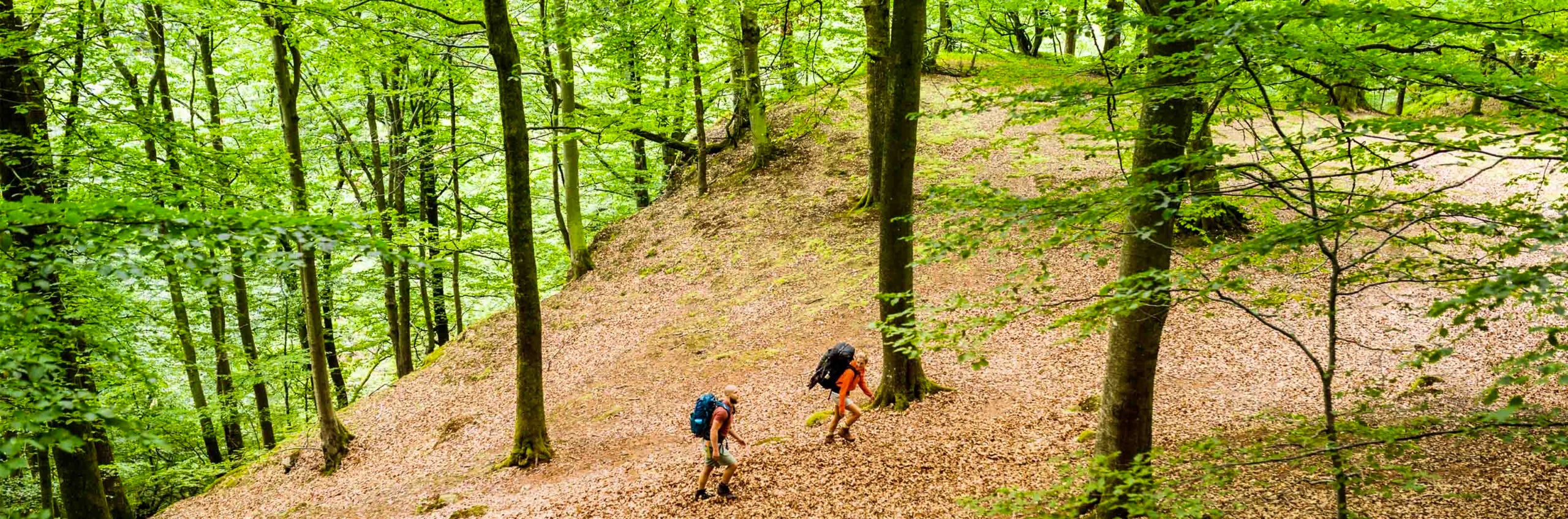
Rolling landscapes, majestic beech forests and deep ravines set the tone for this varied hike. You move through Söderåsen National Park and several scenic walking areas in a landscape shaped by dramatic natural forces.
Within the triangle between Klippan, Hässleholm and Höör lies one of the most volcano-dense areas in the world, with remains from more than 200 volcanoes – several of which you will pass along the way.
Signature trail Skåne runs between Åstorp and Höör and is part of a section of Skåneleden. The full “Skåneleden ås till ås” stretches from Åstorp to Brösarp, but the section between Åstorp and Höör has been selected as one of STF’s signature trails – a particularly scenic and quality-assured multi-day hike.
Please note that the trail passes through several protected natural areas, and you must therefore be aware of the regulations that apply. A good tip is to search for the name of the nature reserve or national park on the Länsstyrelsen Skåne website (opens in new tab) and read more.
Quick facts
Map of Signature trail Skåne
Navigate past map or other external content.This map is a planning tool and should not replace a physical map and compass. The service “Naturkartan” (opens in new tab) is operated by a company called “Outdoor map”. Please note that trail information is owned and updated by the respective trail administrator (e.g. municipality or county administrative board).
See and do along the trail
Be sure to explore the Klöva Hallar Nature Reserve, which is just as spectacular as Söderåsen National Park. Along the trail, there are plenty of accommodations and cafés to add an extra touch of comfort to your hike.
Don’t miss
Bring your swimwear! The trail passes by several beautiful lakes and rivers. If you prefer a quieter experience, consider hiking outside of the peak vacation weeks, as this area can be popular with visitors.
Transport to the trail
By train with Skånetrafiken (opens in new tab) serving both Åstorp and Höör.
Trail markers
The trail is marked with orange signs. You will also find other markers on tree trunks and wooden posts.

Stages of Signature trail Skåne
Stage 1: Åstorp–Krika Skog
21 kilometers, 4–6 hours of hiking
Accommodation: Söderåsens Forsgård (opens in new tab) or shelter/tent at Krika Skog
Start your hike from Åstorp train station, following jogging trails and accessible paths. You’ll pass through deciduous forests, interesting marshlands, and a large stone wall. After 10 kilometers, you’ll reach Hålebäck campsite, where seasonal water is available. From here, the trail becomes more hilly as you enter the Klöva Hallar Nature Reserve with its impressive beech forests. The steep ravine is flanked by high plateaus, and the Klövabäcken stream flows at the bottom. If you wish, you can detour to Söderåsens Forsgård or continue for the final 4 kilometers to the Krika Skog campsite. Drinking water is available at the club house in summer.
Stage 2: Krika Skog–Klåveröd
14 kilometers, 3–4 hours of hiking
Accommodation: STF Klåveröd Logi & Café or shelter/tent at Klåveröd campsite
The trail continues through lush beech forests and mixed woodland. At Klövamölla, the landscape opens up, and you’ll pass through scenic pasturelands. After following a gravel road past Skåne’s highest point, you enter the Klåveröd Recreation Area. Soft trails lead you past geological features like Snuvestuan’s small cave, the scree slopes of Vargadalen, and the peat formations of Skorstensdalen. This area has dense forests, small lakes, and streams. Near Svartesjö, you’ll hike along the Klövabäcken stream near the edge of Söderåsen National Park. Take a detour to Traneröd’s bog, a nearly untouched bog with unique vegetation. The endpoint at Klåveröd offers a hostel and café, and the Klåveröd campsite is a short distance away. There’s a hand pump at the campsite, but the water needs to be treated.
Stage 3: Klåveröd–Röstånga
13 kilometers, 3–5 hours of hiking
Accommodation: STF Villa Söderåsen, Pensionat Söderåsen (opens in new tab), or Camping Röstånga (opens in new tab)
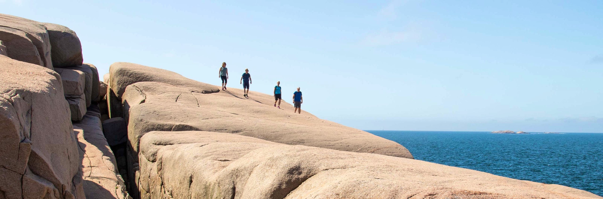
A rocky trail alongside the Dejebäcken stream takes you from Klåveröd Recreation Area into Söderåsen National Park, through Dejebäcksdalen with its beech forests and steep slopes. At Korsskär, where two streams meet, you’ll find a peaceful wilderness spot featuring a five-meter waterfall. After 6 kilometers, you’ll pass Skäralid, which has a visitor center, accommodations, and dining. Continue up the steep path south of Skärdammen to visit Hjortsprånget, a viewpoint with stories of legend. The trail then leads through the small hills of Ugglerödsdalen and Nackarpsdalen, passing the mystical Odensjön lake. End your day in Röstånga (15 km), where several accommodations and services are available.
Stage 4: Röstånga–Hultarp/Hallaröd
23 kilometers, 6–8 hours of hiking
Accommodation: STF Nyrups Naturhotell, Ullstorps Stugor (opens in new tab), or shelter/tent at Hultarp campsite
This is an easy section with winding trails through pastures and woodlands. You’ll pass the volcanic remnant Jällabjär. A few hundred meters north of the triangle point, you can see the remains of a volcanic crater with hexagonal basalt columns. Climb to the viewpoint at Natthall for views over the Rönne River. A footbridge leads you through natural pasturelands with stone walls and into Anderstorps juniper forest. Crossing a suspension bridge over the Rönne River, you’ll see the remnants of historical mills and industries powered by the river. The final stretch is a winding gravel road to the endpoint. If camping, you can shorten your day by camping at Hultarp campsite (13 km from Jällabjär).
If camping, you don’t need to hike all the way to Nyrups Naturhotell, making the route 8 kilometers shorter.
Stage 5: Hultarp–Frostavallen–Höör
19 kilometers, 4–6 hours of hiking
Accommodation: Various options in Höör
The hike continues on trails and smaller roads through the Frostavallen Recreation Area, with open fields breaking up the forested terrain. Volcanic remnants line this section, including Allarps Bjär. Keep an eye out for hexagonal basalt columns, the remnants of old volcanic craters. At Dagstorpssjön, you’ll see more volcanic remnants, including Ulfsbjär near the trail. The basalt in the soil supports a unique flora of sweet woodruff and three types of anemones. A few kilometers later, you’ll pass Hallaröd Church, where seasonal drinking water is available. At the southern tip of Lake Vaxsjön, you’ll walk along the fence of Skåne’s animal park. The area is rich in ancient remains, including a Bronze Age burial cairn southwest of the lake. The last 7 kilometers from Frostavallen to Höör bring you closer to civilization, passing through patches of spruce forest. Don’t miss Onsvalakällan, a spring reputed to have magical water. In Höör, you’ll find accommodations, services, and connections via train and bus for your return trip.

More pages about hiking

All about hiking
On this page you will find helpful tips and information for your hike.

Hiking trails in Sweden
On this page we present a selection of popular and high-quality trails across the country.
Signature trails
STF has selected some of the most spectacular routes in the country and brought them together under the name Signature Trails.